Landslides
Alaska has been facing increasing landslide hazards, driven by more extreme rain, by glacial retreat, and by permafrost thaw. Ground Truth Alaska is on the front lines of studying these hazards and helping communities confront them.
Hig (Bretwood Higman), executive director of Ground Truth Alaska, leads this work. He began his career as a geologist studying the effects of tsunamis, then earthquakes, and has spent the last decade immersed in trying to understand changes in the risk of giant landslides that can generate tsunamis and have other disastrous impacts.
Taan Fiord
We first got involved in this work in the wake of the 2015 landslide and tsunami in Taan Fiord. At the time this event had few precedents since the Lituya Bay tsunami in 1958, and we helped organize a large research team that produced an overview paper on the event, as well as studies of the landslide, the submarine impacts, coastal change, and the tsunami. We also worked with the National Park Service to make a short documentary on the field survey.
Grewingk Glacier Lake
WIth the dramatic evidence of how powerful these disasters can be, we began trying to understand where we might worry about future disasters. This started at Grewingk Glacier Lake, which had a tsunami in 1967. The mountain above the lake has giant cracks in it, and the shore is now a popular tourist destination. We helped spur research by a team of scientists from Germany, and helped Kachemak Bay State Park develop informational signs that are mounted near the lake.
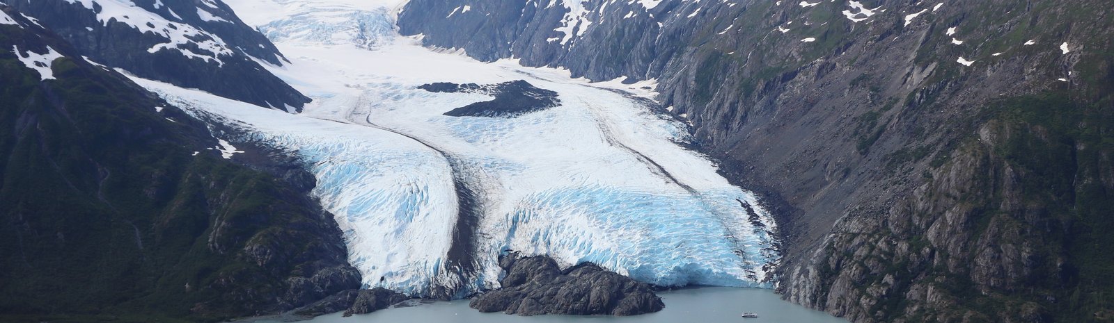
Barry Arm
In 2020 we contributed to research that stumbled across a giant slow-moving landslide at Barry Arm. Through an open letter led by Hig, a group of researchers raised the concern that this slow landslide could fail catastrophically and threaten the town of Whittier with a tsunami. This gained widespread media attention, and helped catalyze the National Landslide Preparedness Act which funds US Geological Survey and Alaska DNR landslide program work that continues in the area.
Statewide studies and collaborations
One of the take-homes Hig took from this dramatic discovery was that nobody was really looking to see where there were signs of potential disastrous landslides in Alaska. For the last several years, he’s been working to map and understand this risk, helping spur research, community engagement, and preparation for these hazards.
Also this helped spur a broad collaboration to confront this hazard, including community members, academics, and agency personnel. In particular, a National Science Foundation planning grant under the banner of Arctic T-SLIP is helping build coordinated scientific proposals on many aspects of landslide risk. This has also been key to fostering collaboration with Kutí based out of Sitka, which is seeking to address disastrous shallow landslides such as those that happened in Sitka, Haines, Wrangell, and Ketchikan in recent years.
Another aspect of this work has been systematically documenting the many landslides across Alaska, leading to a publication with the USGS as well as academic studies.
Portage Lake
At Portage Lake, a popular tourist destination next to critical infrastructure corridors, the bedrock of a tall slope is breaking and shifting downward toward a glacier below. In other places like this with cracking bedrock moving meters per year downslope, above a retreating and thinning glacier, catastrophic landslides have occurred. Following several years of research studying the slope with colleagues from Germany and Switzerland, as well as growing public concern, we have entered a cooperative agreement with Chugach National Forest to deploy prototype monitoring instruments and produce analyses to support further mitigation. In September 2025 a large rain storm that coincided with a moderate sized landslide triggered a cautionary message from the Forest Service, and the evacuation of their visitor center.
Glacier View
Further northwest near the community of Glacier View, several recent catastrophic landslides raise the concern that disaster could strike the highway or part of the community. We identified two particularly urgent issues, one now dubbed the “Matanuska Narrows Instability” and the other on Streishla Mountain above a neighborhood and bible camp at Index Lake. We are collaborating with the camp to deploy monitoring equipment in hopes that this could provide some warning if failure was imminent.
Columbia Fjord
In many ways the large slow landslide we identified at Columbia Fjord is remote, however it is a place that gets regular visitation by vessels including tour boats with 100s of people on board. It’s also a great site to study the dynamics of a landslide like this, and in 2022 our collaborator Noah Finnegan was awarded funding for an NSF study that included this site and one in California. This research is nearing its conclusion, and has identified complex responses to precipitation that influence landslide seismicity.
Pedersen Lagoon
This work has also extended to further studies in places where landslides have happened. In 2024 a landslide above Pedersen Glacier fell onto the glacier and slid off the face, generating a very large tsunami. While initial reports cited a 17 m maximum runup, when we surveyed the impacts a month later we found the traces of the wave as high as 62 m above the water.
Tracy Arm
2025 has been a very active year for landslides, including the dramatic Tracy Arm landslide and tsunami south of Juneau. Our current best-estimate of the highest runup for this event is 480 m, and Ground Truth Alaska is helping lead an expedition to the area in mid October 2025.
Risk for Vessels
Many areas of the landslide-generated tsunami risk are remote from homes and roads, but frequently visited by vessels. There is little advice to vessel operators should they face a disaster of this sort, and we helped organize a workshop in Valdez to bring scientists and vessel operators together. So far this has resulted in a report on the idea, and we hope to see refinements to guidance for vessel operators coming in the future.
Other areas of concern
There are numerous sites where the potential of landslides sits close to people, including in Seward, Homer, and Yakutat, where Ground Truth Alaska is helping organize workshops during October 2025, and in the Lemon Creek neighborhood of Juneau where Hig visited in 2021. We have also been engaged in initial examinations of landslide-generated tsunami risk at Eklutna Lake, and raising concerns about increasing landslide activity that threatens the Trans Alaska Pipeline at Atigun Pass and elsewhere.
Feel free to reach out: contact@groundtruthalaska.org